ELAFONISOS . . .
Elafonisos is by far the largest inhabited island in the Peloponnese archipelago, and the only one that is a separate municipality. There are also some archaeological discoveries to explore on the island and in the surrounding waters. The main church of the community is Agios Spyridon (Greek: Άγιος Σπυρίδων), which is built on a tiny separate piece of land which is connected by a bridge over shallow waters to the rest of the island. The community's land area also includes 3 km2 (1 sq mi) of the mainland consisting mainly of the famous Punta Beach.On the nearby mainland, approximately 6.5 km (4.0 mi) east is Neapoli (Greek: Νεάπολη) of the municipality of Vatika. About 8.5 km (5.3 mi) south is Cape Frangos (Greek: Φράγκο) on the island of Kythira.
In antiquity, Elafonisos did not constitute an island but a peninsula with the name "Onou Gnathos" (Greek: Όνου Γνάθος, Donkey's Jawbone) according to Pausanias. Just off the coast of Elafonissos lies the archeological site of Pavlopetri, a sunken city dating back to the early 3rd millennium BC and thought to have been claimed by the sea around 1000 BC.
Elafonisos, located only 300 m from Pounta on the coast of the Peloponnese, looks back on a history of around 5,000 years, as it was already inhabited in the 3rd to 2nd millennia BC, as prehistoric finds prove. During the Peloponnesian War, it was the scene of battles between Athenians and Spartans, as the former had fortified the isthmus connecting the island to Pounta at that time. From 1839 to 1850 it belonged to the English, who considered it part of the Ionian Islands. It is connected to Pounta or Neapolis in Laconia by local ferry services. The island has an area of 20 square kilometres and 750 inhabitants.
Elafonisos has a unique geographical position at the southern end of Mount Parnonas and between the seas. This fact created unique conditions for the development of rare and unique flora and fauna. The special environment can hardly be compared in any other region. Its natural beauty and the uniqueness of its surroundings have led to its designation as a Site of Community Importance. It has been included in the NATURA 2000 ecosystems protected under the code GR2540002 for the conservation of natural habitats and wildlife.
Particularly noteworthy is the rare species of juniper (Juniperus macrocarpa), which occurs both as a shrub and a tree. It can be seen in various parts of the island, such as Lefki, Simos and the area between Chora and Panagia beach.
History of Elafonisos
The first historical examples of the culture of Elafonisos are found in the depths of the centuries. The various archaeological finds that culminated in the oldest sunken state in the world, Pavlopetri, bear witness to this. This great archaeological and historical wealth is due to the important geographical position of Elafonisos on the shipping routes. This important position was exploited by pirates and corsairs to attack ships passing through the Strait of Elafonisos between Elafonisos and Kythera. Moreover, this position was responsible for the occupation of the island and its domination by a variety of peoples such as Arabs, Franks and Saracens.
The existence of life, action and culture on the island thus begins in prehistoric times, and the island is found in numerous accounts by ancient travellers of the temples it houses, as the "acra" of Pausanias (III, 22.10) and the "humble peninsula" of the ancient geographer Strabo (VIII, 5.1). The settlement of the island continued in the course of time, which is also attested by later finds. The island acquired its present form after the devastating earthquake of 375 AD, which also destroyed Pavlopetri and separated Elafonisos from the rest of the Peloponnese.
Traditions and festivals
On Elafonisos, this small island, there are local traditions with a long history. Its intense island colour and culture could hardly be more different from the other islands of the Cyclades and the Ionian Islands, as well as its Laconian neighbours. The influence of the conquerors, the Franks, the Saracens, the Venetians and the people coming from the surrounding areas of Mani, Kythera, Vatika on the island can be seen not only in the names but also in the customs and events on the island.
The scent of an authentic island and country culture is still present in the customs and traditions of the local culture and is reflected in the many local events that visitors should not miss. Some of the most important of these are:
Festival of Saint Spyridon, patron saint of Elafonisos, December 12:
Elafonisos honours the patron saint and protector of the island in the church in the island's harbour.
Three Days of Festivities - 6th July Jubilees & Dedication of the Church of St Spyridon, July 6-9:
Every year Elafonisos commemorates the anniversary of its liberation on 6 July 1850 with the historic and significant contribution of the Maniotes. The three-day event lasts until 9 July, the day on which the religious anniversary of the dedication of the Church of Saint Spyridon is celebrated. Numerous events take place during the three-day period, such as the Festival of Traditional Dance, launched in 2016, with dance groups from Greece and other countries.
Festival of the Fishermen, the last ten days of August:
An integral part of the history and culture of Elafonisos is the Fishermen's Festival, which takes place during the last ten days of August. The Fishermen's Association organises this event with island and local dances by dance groups, live music and plenty of food and fish in honour of visitors to Elafonisos and with wishes for a good sea. The events are often accompanied by presentations and film screenings about the island's folklore and maritime history.
It's worth looking at:
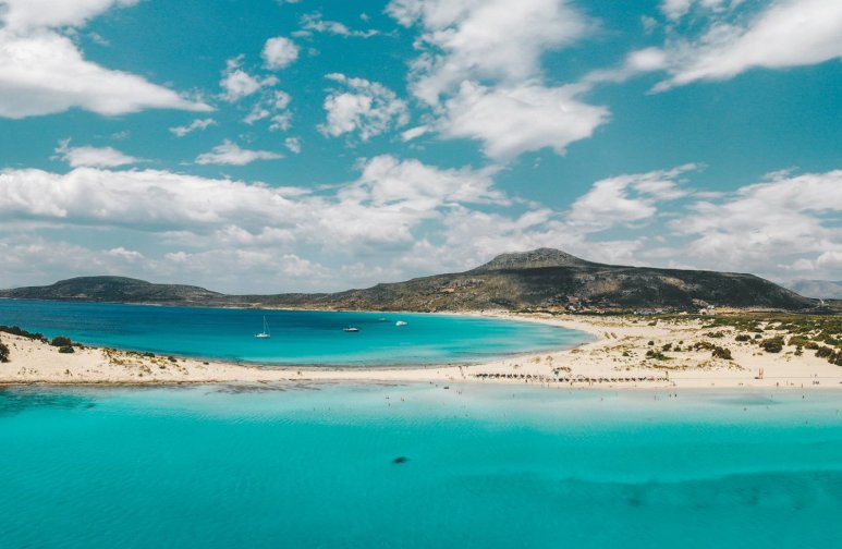
The famous exotic sandy beach of Simos, one of the best in Greece:
 |
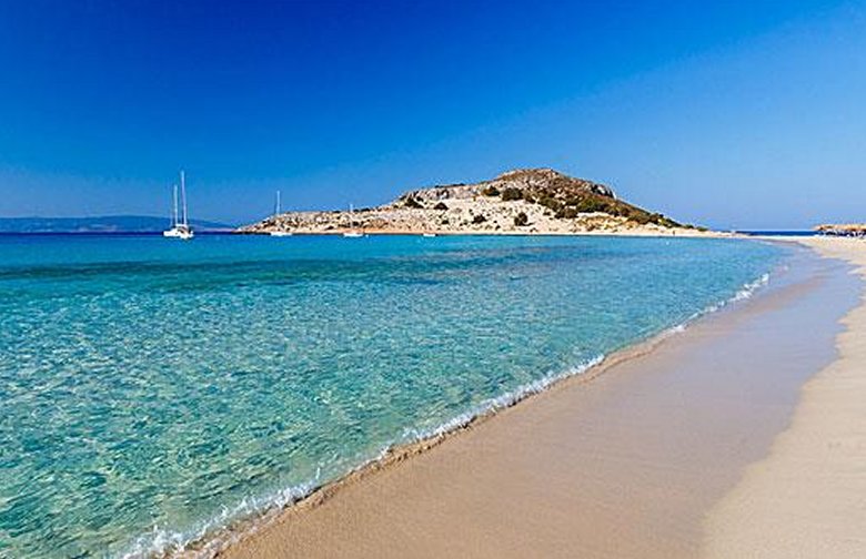 |
Beach of Simos
On the south-eastern side of Elafonisos and in the area of Lefki is the beach of Simos. Between two small peninsulas, Frangos and Sarakinikos, overlooking Kythera with unique turquoise waters and golden sand, the well-known beach of Simos promises the visitor unique moments of relaxation. The small bay, Frangos Bay, is protected from the waves and the shallow waters ensure easy and safe access to the sea and swimming. The landscape is complemented by the large dunes and the unique cedar forest that extends to the neighbouring beach of Sarakinikos.
The beach seems to be named after the sponge diver Simos of Kalymnos, who drowned near Frangos. Its beauty is the reason for the recognition that the island of Elafonisos enjoys today.
Simos, which used to be a destination for visitors who wanted to camp for free, now has all the necessary infrastructures and catering establishments to satisfy all visitors. It is located about 4.5 km from the town of Elafonisos and is accessible by car via a paved road. In summer, small boats also operate from the old port of Elafonisos.
The ancient sanctuaries of Athena, Poseidon and Apollo.
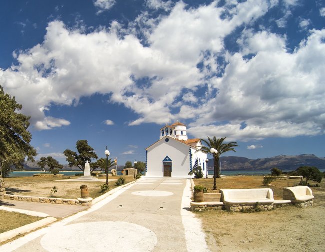
The Church of Saint Spyridon, built on a rock and offering a magnificent sunset:
 |
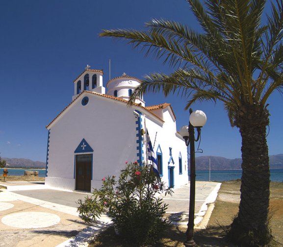 |
Church of Saint Spyridon
The church of St. Spyridon, built on a small piece of land connected to the settlement by a bridge over shallow water, is the main church of the municipality of Elafonisos and a landmark of the island.
The church dominates the entrance to the port of Elafonisos.
The islets of Kassella, Gaidouronissi, Lepto and Agia Sophia.
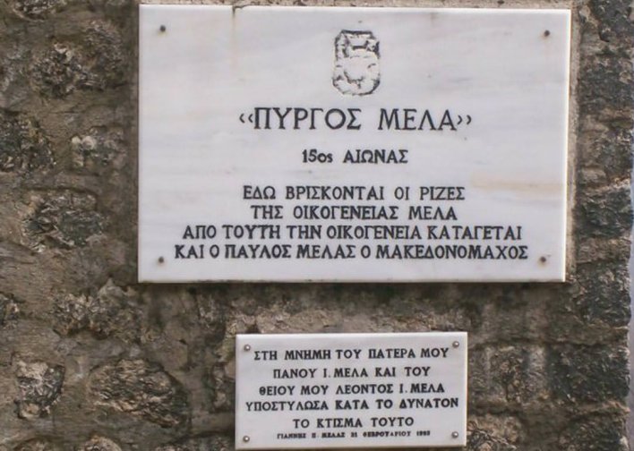
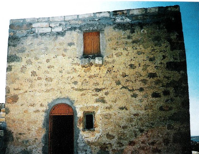
The Tower of Meladon:
 |
 |
Tower of Meladon
In the area of Kato Nisi is the "Tower of Meladon" (Melas family castle), a two-storey Mani-style defence tower on the highest point of an 11-hectare estate. Built in the late 1800s for defensive purposes, the estate is now used for vegetable cultivation and livestock breeding. Visitors are invited to tour the tower, enjoy the spectacular panoramic view of the Laconian Gulf from the top of the building, sample local delicacies and hear the interesting history of the estate and the generations of its owners.
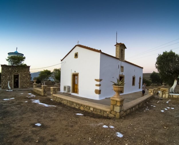
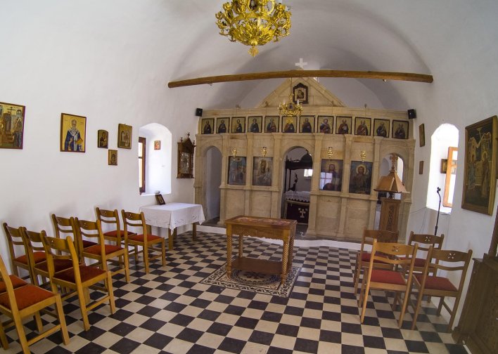
The Church Virgin of Katoniotissa:
 |
 |
Church Virgin of Katoniotissa
Church Virgin of Katoniotissa, Assumption of the Virgin Mary, gave its name to the beautiful beach of Panagia (Kato Nisiu beach) and the small islands surrounding it (Panagia islands). The church was built around 1895 on a hill on the ruins of an old Byzantine church, according to the local authorities. Materials and stones from the old Byzantine church were used. Inside the sanctuary, old hagiographies can still be seen. Traces of the Mycenaean civilisation can be found around the church. It is said that the church was a temple of Athena in ancient times.
Pavlopetri:
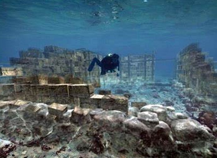 |
 |
Pavlopetri
The city of Pavlopetri (Greek: Παυλοπέτρι), underwater off the coast of southern Laconia in Peloponnese, Greece, is about 5,000 years old, making it one of the oldest submerged lost cities, as well as the oldest in the Mediterranean sea. Pavlopetri is unique in having an almost complete town plan, including streets, buildings, and tombs.
Discovered in 1967 by Nicholas Flemming and mapped in 1968 by a team of archaeologists from Cambridge, Pavlopetri is located between the islet of Pavlopetri and the Pounta coast of Laconia on the Peloponnese peninsula. The site is northeast of the village on the island of Elafonisos. The archeological site as well as the islet and the surrounding sea area are within the region of the Elafonisos Municipality, the old "Onou Gnathos" peninsula (according to Pausanias).
Originally, the ruins were dated to the Mycenaean period, 1600–1100 BCE but later studies showed an older occupation date starting no later than 2800 BCE, so it also includes early Bronze Age middle Minoan and transitional material. It is now believed that the town was submerged around 1000 BCE by the first of three earthquakes that the area suffered. The area never re-emerged, so it was neither built-over nor disrupted by agriculture. Although eroded over the centuries, the town layout is as it was thousands of years ago. The site is under threat of damage by boats dragging anchors, as well as by tourists and souvenir hunters.
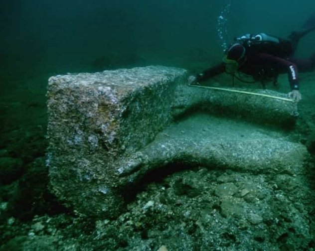
he fieldwork of 2009 was largely to map the site. It is the first submerged town digitally surveyed in three dimensions. Sonar mapping techniques developed by military and oil prospecting organizations have aided recent work. The city has at least 15 buildings submerged in 3 to 4 metres (9.8–13.1 ft) of water. The newest discoveries in 2009 alone cover 9,000 m2 (2.2 acres).
Four more fieldwork sessions were planned in October 2009, in collaboration with the Greek government as a joint project aimed at excavations. Also working alongside the archaeologists (from the University of Nottingham) are a team from the Australian Centre for Field Robotics, who aim to take underwater archaeology into the 21st century. Several unique robots have been developed to survey the site in various ways. One of the results of the survey was to establish that the town was the centre of a thriving textile industry (from the many loom weights found in the site). Also many large pitharis pots (pottery jars) from Crete were excavated, indicating a major trading port.
The city of Pavlopetri is part of the underwater cultural heritage as defined by the UNESCO in the UNESCO Convention on the Protection of the Underwater Cultural Heritage. All traces of human existence underwater which are one hundred years old or more are protected by the UNESCO Convention on the Protection of the Underwater Cultural Heritage. This convention aims at preventing the destruction or loss of historic and cultural information and looting. It helps states' parties to protect their underwater cultural heritage with an international legal framework.